

How will our landscape develop in the future? What influence will climate change and increasingly intensive land use have on biodiversity? Computer-based simulation models can help to analyse the increasingly complex issues and derive adaptation measures to minimise negative impacts.
Landscape modelling
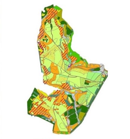
Simulation of the vegetation development of a real landscape
As a decision support system for complex ecological systems, we use landscape modelling to simulate the vegetation development of a real landscape
Decision support through computer-based simulation models
Landscape modelling
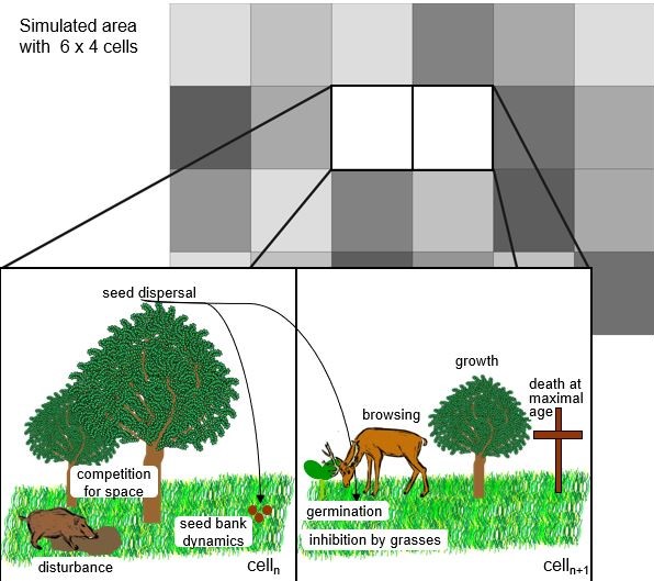
The GraS model developed by gaiac enables analyses and forecasts of the vegetation dynamics of real landscapes depending on different stressors as well as different management measures. The GraS model was used for management decisions in the Eifel National Park (Germany) and to analyse the natural regeneration processes of the Kyrill windthrow areas in North Rhine-Westphalia. It is currently being used to determine the flower supply of honey bee colonies in agricultural landscapes and to research the effects of climate change on floodplain landscapes.
Ecological modules in decision support systems
In addition to the application of its own simulation models, gaiac is active in the development and implementation of ecological modules in interdisciplinary decision support systems. GIS-based modules for analysing the blue-green infrastructure of settlement areas have been developed and tested, as well as modules for carrying out vulnerability analyses and monetising ecological damage during extreme events.


Note: By clicking on the video you will leave our website and be redirected to the website www.youtube.com. For more info, please see our privacy policy.
The GraS model takes into account
9
essential environmental factors.
The GraS model includes approx.
15
grasses and herbaceous plants as individual species or functional groups and
25
tree species.
The GraS model was developed for
4
different ecosystem types.


References
Projects
2020-2023
VIBee - Etablierung digitaler Indikatoren der Bienenvitalität in Agrarlandschaften | BLE, FKZ 906370
Project website2020-2023
R2K-Klim+ - Strategisches Entscheidungsunterstützungstool zur Anpassung an den Klimawandel auf regionaler und kommunaler Ebene im Rheineinzugsgebiet | BMBF, FKZ 01LR2008B
Project website2017-2018
Bio-Tip - FORD - Bio-Tip Verbund: Nachhaltige Waldentwicklung und Forstwirtschaft - Wald Greening Konzept, Teilprojekt 1 Projektkoordination, Ökologische Waldbehandlungsoptionen und ihre Effekte auf die Waldentwicklung | BMBF, FKZ 01LC1716A
2012-2015
RISKMIN - Entwicklung landschaftsbezogener Risikominderungsmaßnahmen zum Schutz der terrestrischen Agrobiodiversität (Pesticide risk mitigation at landscape level – A spatial approach to maintain and develop agrobiodiversity) | BVL, FKZ123-02.05-20.0024/1
Project report2011-2013
Der Virtuelle Wald III - Entwicklung moderner Verfahren für ein integriertes Großraumwaldinformationssystem und die effiziente technische Produktion in der Waldwirtschaft zur zielgerichteten Rohstoff-Mobilisierung und -Bereitstellung für die Holzwirtschaft. Teilprojekt: IT-basierte Simulation natürlicher Waldentwicklungsprozesse von offenen bzw. halboffenen Flächen in Waldgebieten | EFRE, FKZ 210-6017-8311
Further informationVideo2012-2013
Graphische Auswertung und Visualisierung des Monitorings zur Entwicklung des FFH-Lebensraumtyps Hainsimsen-Buchwald | Lehr- und Versuchsforstamt Arnsberger Wald
2009-2010
JARA Seed Project - Parallelization of the GraS-Model for Detailed Spatial Prediction of Grassland Succession | Funded by the German Excellence Initiative
2006-2009
REISE - Entwicklung ökologischer Bewertungsmethoden. Projektteil im BMBF-Verbundprojekt: Entwicklung eines risikobasierten Entscheidungshilfesystems zur Identifikation von Schutzmaßnahmen bei extremen Hochwasserereignissen | BMBF
2004-2006
Modellierung von Landschaftsentwicklungsszenarien für die Managementzone im Nationalpark Eifel unter Berücksichtigung verschiedener Managementvarianten einschließlich spezieller Untersuchungen der Heuschrecken, Tagfalter und Vögel sowie der Ableitung von Monitoringparametern für die Offenlandentwicklung | MUNLV (LÖBF) NRW
Publications & Presentations
2023
Rumohr, Q., Grimm, V., Lennartz, G., Schäffer, A., Toschki, A., Roß-Nickoll, M., Hudjetz, S. (2023): LandS: Vegetation modeling based on Ellenberg’s ecological indicator values. MethodsX 11: 102486. DOI: https://doi.org/10.1016/j.mex.2023.102486.
2019
Hudjetz, S., Hammers-Wirtz, M., Lennartz, G., Strauss, T., Toschki, A. (2019): The GraS model – Simulating the vegetation dynamics for a raster-based landscape. Platform presentation, SETAC Europe 29th Annual Meeting, 26-30 May 2019, Helsinki, Finland.
2017
Roßmann, J., Bücken, A., Lennartz, G., Hudjetz, S. (2017): Remote sensing based forest management in conjunction with a succession simulation. Chapter in Proceedings of the 17th International Multidisciplinary Scientific GeoConference SGEM 2017, Vienna GREEN, 27-29 November 2017, Vienna, Vol. 17, Issue 33: 625-632, ISBN: 978-619-7408-27-0.
2014
Hudjetz, S., Lennartz, G., Krämer K., Roß-Nickoll, M., Gergs, A., Preuss, T. G. (2014): Modeling wood encroachment in abandoned grasslands in the Eifel National Park – Model description and testing. PLoS ONE 9 (12): e113827. DOI: 10.1371/journal.pone.0113827.
2014
Siehoff, S., Strauss, T., Lennartz, G. (2014): Simulation of natural reforestation after windthrow – subproject of the Virtual Forest (Virtueller Wald) NRW. Climate Change and Nature Conservation in Europe – an ecological, policy and economic perspective. BfN-Skripten 367: 179-180.
2012
Lennartz, G., Leder, B., Schmitz, K. H., Siehoff, S. (2012): Natürliche Entwicklung von Windwurfflächen in NRW - dynamische und gebietsspezifische Prognosen. Schriftenreihe Natur in NRW, Heft 4/12.
2011
Siehoff, S., Lennartz, G., Heilburg, I., Roß-Nickoll, M., Ratte, H. T., Preuss, T. G. (2011): Process-based modeling of grassland dynamics built on ecological indicator values. Ecological Modelling 222: 3854-3868.
2011
Siehoff, S., Lennartz, G., Heilburg, I., Roß-Nickoll, M., Ratte, H. T., Preuss, T. G. (2011): Process-based modeling of grassland dynamics built on ecological indicator values. Ecological Modelling 222: 3854-3868. DOI: 10.1016/j.ecolmodel.2011.10.003.
2010
Lennartz, G., Ruckes, A., Heyn, T. (2010): Regionaler Portfoliomanager - ein Online-Kalkulationstool zur wohlfahrtsökonomischen Flächenbewertung, Schriftenreihe Landesumweltamt Sachsen.
2009
Lennartz, G., Siehoff, S., Roß-Nickoll, M., Preuss, T. G. (2009): Modellierung von Landschaftsentwicklungsszenarien der Offenlandflächen im Nationalpark Eifel unter Berücksichtigung verschiedener Managementvarianten (Grasland Sukzessions-Modell). In: Finck, P., Riecken, U., Schröder, E. (Hrsg): Naturschutz und Biologische Vielfalt, BfN-Schriftenreihe, Landwirtschaftsverlag, Münster, Heft 73: 229-241.
2009
Huber, N. P., Bachmann, D., Petry, U., Pahlow, M., Schumann, A. H., Bless, J., Lennartz, G., Arránz-Becker, O., Altepost, A., Kufeld, M., Pahlow, M., Romich, M., Fries, J., Schüttrumpf, H., Köngeter, J. (2009): Ein Konzept für eine risikobasierte Entscheidungshilfe im Zuge der Identifikation von Schutzmaßnahmen bei extremen Hochwasserereignissen. Hydrologie und Wasserbewirtschaftung, Heft 3.
2009
Huber, N. P., Bachmann, D., Schüttrumpf, H., Köngeter, J., Petry, U., Pahlow, M., Schumann, A. H., Bless, J., Lennartz, G., Arránz-Becker, O., Romich, M., Fries, J. (2009): An integrated risk-based multi criteria decision-support system for flood protection measures in riversheds - REISE. In: Research and Practice; Proceedings of the European Conference on Flood Risk Management - Research into Practice (Floodrisk 2008), Oxford, UK, Vol. 30: 93-829.
2008
Lennartz, G., Fürste, A., Theißen, B., Toschki, A., Siehoff, S., Roß-Nickoll, M., Schäffer, A., Preuss, T. (2008): Das GraS-Modell (Grasland Sukzessions Modell) - eine Entscheidungshilfe bei der Auswahl möglicher Managementvarianten für zukünftige Landschaftsentwicklungen (dargestellt am Beispiel des Nationalparks Eifel). In: Lennartz, G. (Hrsg.): Naturschutz und Freizeitgesellschaft. Renaturierung - Programmatik und Effektivitätsmessung 8: 172-191.
2006